
A few rounds of showers are expected to move through the area today with the first already making its way into western NH this morning. These storms have the potential to produce locally heavy rainfall and gusty winds which may result in flash flooding. #NHwx #MEwx pic.twitter.com/ehlFeQ2FpG
— NWS Gray (@NWSGray) August 4, 2023
Widespread showers and thunderstorms are expected through Friday in Maine.
Flooding and gusty winds are possible with any storms. Big improvements arrive this weekend as dry air and sunshine returns.
Warm, sunny conditions continue into early next week.
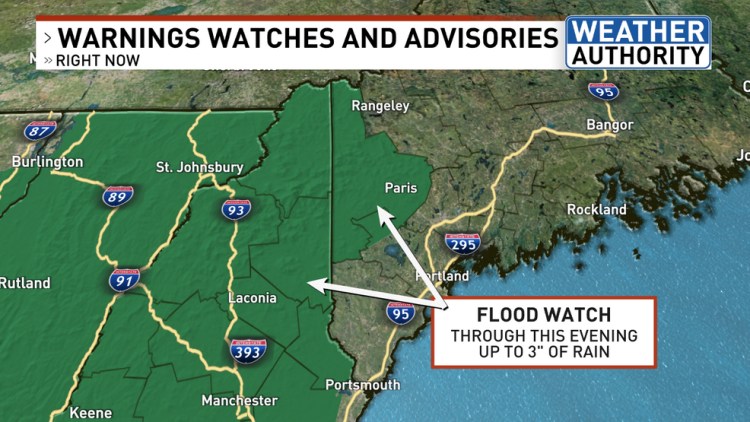
A heavier round of showers and storms then arrives for the afternoon and evening. With very heavy rain, flash flooding is possible. A flood watch is in place for parts of the state until Friday evening. Gusty winds are also possible with any storms.

Showers and storms come to an end late this evening. Big improvements arrive heading into Saturday.
The sun comes out Saturday morning, but it will still be humid.
Dry air gradually moves in through the day, feeling much more comfortable by the afternoon.
Highs will be near 80 with plenty of sun.
Sunday will be near-perfect. Dry air, lots of sun, and highs again near 80 will make for some incredible weather for getting outdoors.

Nice again Monday, but humidity will increase ahead of more widespread showers and storms on Tuesday.
Our next shower and storm chance arrives next Tuesday.
Beyond Tuesday’s wet weather, more sunshine and summer warmth is in store for the middle and latter part of next week. Highs will be in the low to mid 80s.
Comments are no longer available on this story